


Introduction
Bangladesh, a developing nation in South Asia, is one of the most flood-prone countries in the world. Approximately 75% of the country is classified as a floodplain, and nearly 80% of the land lies below 10 meters above sea level (Smith, 2021). With over 91% of river basin runoff entering through the Ganges, Brahmaputra, and Meghna river systems, Bangladesh is exposed to annual and often devastating floods. The monsoon season, typically spanning from July to September, marks the peak flooding period, exacerbating socioeconomic vulnerabilities and threatening national development (Rahman & Hossain, 2020).

Main Causes of Flooding in Bangladesh
Flooding in Bangladesh results from a combination of natural and anthropogenic factors. The most significant causes include:
- Heavy Monsoon Rainfall: During monsoon periods, some areas in the Ganges basin receive over 500 mm of rainfall in a single day, contributing to river overflow (Ahmed et al., 2023).
- Tectonic Uplift and Sediment Deposition: The Himalayas' tectonic uplift increases sediment transport. This sediment chokes river channels, reducing their hydraulic capacity and causing overbank flooding (World Bank, 2020).
- Himalayan Snow and Glacier Melt: Snowmelt during spring and summer adds to river discharge, often coinciding with monsoon rains and raising flood peaks (Chowdhury, 2022).
- Convergence of Major Rivers: The Ganges, Brahmaputra, and Meghna rivers converge in Bangladesh, amplifying the volume of water and the risk of synchronised peak flows. When the peaks coincide, as in 1988 and 1998, catastrophic flooding results (Islam & Uddin, 2021).
- Cyclones and Storm Surges: Tropical storms in the Bay of Bengal cause storm surges that flood coastal areas, affecting around 12,000 sq. km of land (BBS, 2021).
- Flash and Tidal Floods: The northeastern hilly rivers cause flash floods in April–May, while tidal floods from the Bay of Bengal occur twice daily in the coastal southwest and south-central regions (Reza et al., 2023).
- Deforestation and Urbanisation: Deforestation in upstream regions reduces interception and increases runoff. Urbanisation leads to wetland encroachment, poor drainage infrastructure, and riverbed siltation, all worsening flood impacts (Masoom & Ahmed, 2023).

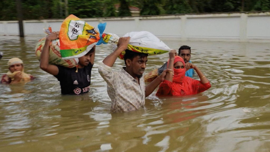
Impacts of Flooding
The consequences of floods in Bangladesh are extensive and multifaceted. On average, 18–30% of the land is inundated annually, with up to 75% affected in extreme cases, such as in 1988 (Smith, 2021).
- Displacement and Mortality: In the 2007 flood, approximately 9 million people were rendered homeless, and nearly 1,000 lost their lives (UNDP, 2008).
- Health Crises: Floodwaters often cause outbreaks of waterborne diseases such as diarrhoea and dysentery. In 2004, 100,000 people in Dhaka alone suffered from diarrhoea (BBS, 2021).
- Damage to Agriculture: Flooding devastates rice, jute, and sugarcane crops. In 2007, 2.2 million acres of cropland were destroyed, with $290 million in damages (FAO, 2009).
- Infrastructure Losses: Bridges, roads, and schools are frequently damaged or destroyed. The 2004 floods caused an estimated $7 billion in infrastructure losses (World Bank, 2020).
- Economic Disruption: The disruption of transport and trade routes hampers relief efforts and slows economic recovery.

Flood Events of Note
- 1988: Massive flooding affected 75% of the country due to synchronised river peaks.
- 1998: Another catastrophic flood with extensive damage and displacement.
- 2004: 600 deaths, 30 million displaced, and severe economic impacts.
- 2007: A regional disaster affecting 46 out of 64 districts in Bangladesh.
Responses to Flooding
Short-term Responses:
- Emergency food aid and water purification tablets.
- Embankment repairs and rescue operations.
- Distribution of free seeds to farmers to replant lost crops (UNDP, 2008).
Long-term Responses:
- Construction of embankments to contain rivers.
- Development of raised flood shelters to protect people and livestock.
- Implementation of flood warning systems and emergency planning (Masoom & Ahmed, 2023).
- Plans for dams and catchment management.
- Reforestation to reduce runoff and improve water retention.
due to limited funding and technical capacity. Maintenance is irregular, and many solutions are only partially effective or fail to reach the most vulnerable populations.

Human and Environmental Challenges
- Poor Drainage Infrastructure: Many urban and rural areas suffer from blocked drainage systems due to solid waste and inadequate canal maintenance (Islam & Uddin, 2021).
- Encroachment of Wetlands: Urban development continues to reduce natural flood buffers like ponds and beels.
- Riverbed Siltation: Sediment buildup decreases river capacity, worsening flood levels.
- Socioeconomic Vulnerability: Over 45 million people live in flood-prone areas, many of whom are poor, food-insecure, and lack access to healthcare and education (BBS, 2021).
Bangladesh faces an urgent need to strengthen its flood resilience, particularly in light of climate change and sea level rise. A 1.5-metre rise in sea level could inundate 22,000 km² of land and displace 17 million people, threatening agriculture, fisheries, and coastal cities like Chittagong (Chowdhury, 2022).
Comprehensive and integrated flood management involving all stakeholders—including government, NGOs, local communities, and international partners—is essential. This includes data-driven planning, resilient infrastructure, and enhanced community awareness. Improved governance, funding transparency, and proactive policy implementation are key to avoiding another cycle of disaster and recovery.
Conclusion
Flooding in Bangladesh is a complex, multi-dimensional issue rooted in geographic, climatic, and human-induced factors. But notable strides have been made in flood management; the frequency and intensity of flood events continue to rise. With over 45 million people at risk and climate change accelerating these threats, a collaborative, long-term approach to flood governance is not just necessary—it is imperative for national sustainability.
References
Ahmed, R., Hossain, M., & Khan, M. (2023). Monsoon Rainfall and Its Hydrological Impact in South Asia. Dhaka: BIDS.
Bangladesh Bureau of Statistics (BBS). (2021). Multiple Indicator Cluster Survey. Dhaka: BBS Publications.
Chowdhury, A. (2022). Climate Change and Water Security in the Bengal Delta. Springer.
FAO. (2009). Impact of 2007 Floods on Agriculture in Bangladesh. Rome: Food and Agriculture Organisation.
Islam, M. R., & Uddin, S. M. (2021). Flood patterns in Bangladesh: A historical perspective. Journal of South Asian Environmental Studies, 18(3), 145-162.
Masoom, M. R., & Ahmed, I. (2023). Structural and Qualitative Challenges in Bangladesh's Primary Education. Dhaka Tribune Studies.
Rahman, H., & Hossain, A. (2020). Geographical vulnerabilities and disaster management in Bangladesh. Dhaka: University Press Limited.
Smith, D. (2021). Flooding in Bangladesh: Past, Present, and Future. Nature Climate Reports, 34(4), 210-228.
UNDP. (2008). Disaster Response Evaluation: Bangladesh Floods 2007. New York: United Nations Development Programme.
World Bank. (2020). Bangladesh Flood Risk Assessment Report. Washington, DC: World Bank Publications.